


About the trek
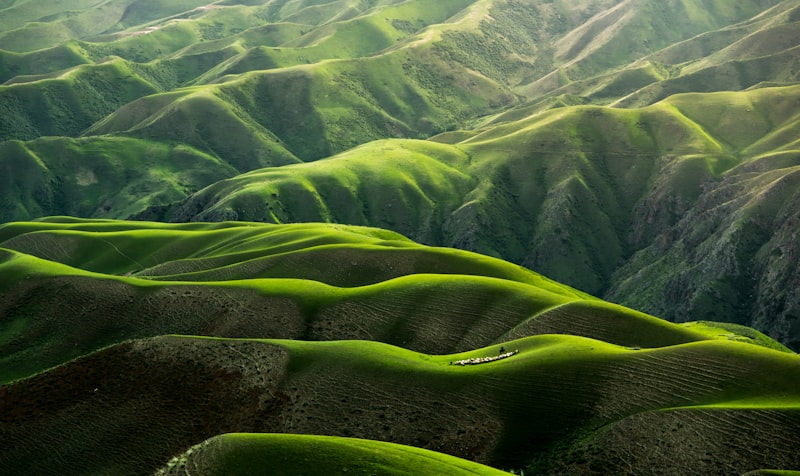
Imagine stepping into a world where every turn reveals a new tapestry of lush greenery, vibrant wildflowers, and serene alpine meadows. This is the Routeburn Track, a 32km traverse through Fiordland National Park and Mount Aspiring National Park. As you hike, the crisp air fills your lungs, and the symphony of nature surrounds you. The alpine Harris Saddle, at 1255m, offers panoramic views that stretch as far as the eye can see. This trek is not just a journey through terrain; it's an immersive experience in natural beauty. You'll find yourself captivated by the ease of access to stunning scenic vistas, making it a perfect blend of adventure and relaxation. Whether you're a seasoned trekker or a beginner, the Routeburn Track promises an emotionally enriching and physically rewarding experience.
Key Facts
Why Trekkers Love It
- 01Spectacular 32km traverse through two national parks.
- 02Iconic alpine Harris Saddle offering panoramic views.
- 03Lush, meadow-like landscapes with vibrant wildflowers.
- 04Often combined with the Milford Track for an ultimate South Island experience.
More Photos
Photo Gallery
5 photosDay by Day
The Route
Route & Itinerary
Routeburn Shelter
🚩 Starting Point
Routeburn Flats Hut
Waypoint 1
Routeburn Falls Hut
Waypoint 2
Harris Saddle
▲ Highest Point
Lake Mackenzie Hut
Waypoint 4
The Divide
🏁 End Point
Altitude
Elevation Profile
Routeburn Shelter
390m
Routeburn Flats Hut
550m
Routeburn Falls Hut
1,005m
Harris Saddle
1,255m
Lake Mackenzie Hut
920m
The Divide
532m
Start
390m
Peak
1,255m
Total Gain
+865m
When to Go
Monthly Climate Guide
Best months to trek: Oct, Nov, Dec, Jan, Feb, Mar, Apr. Avoid Jun, Jul, Aug — heavy rainfall makes trails risky.
Jan
BESTCold & Snowy
-5–8°C
Feb
BESTSnowy
-3–10°C
Mar
BESTOpening
2–15°C
Apr
BESTPleasant
8–20°C
Jun
NOWMonsoon Onset
12–22°C
Oct
BESTBest Season
5–18°C
Nov
BESTCold
0–12°C
Dec
BESTSnowy
-5–5°C
Getting There
How to Reach
Nearest Airport
Queenstown Airport, Queenstown, 60km
Nearest Railway
No railway station nearby
Flight to Queenstown (23hrs) + bus (1hr), ₹30,000
Not feasible
Not feasible
Flight to Queenstown (24hrs) + bus (1hr), ₹32,000
Not feasible
Not feasible
Flight to Queenstown (25hrs) + bus (1hr), ₹35,000
Not feasible
Not feasible
Last Mile to Base Camp
Bus or shuttle from Queenstown to Routeburn Shelter
Pro tip: Book your transport and permits in advance to avoid last-minute hassles.
Costs
Budget Breakdown
Trek costs ₹15,000–₹35,000 depending on your style and whether you hire a guide
Mid-Range Trek
Guide + porter, comfortable guesthouses
per day
₹6,667 – ₹8,333 per day
Prices are estimates for 2025–26. Costs vary by season and group size.
Preparation
Pack & Stay Safe
What to Pack
gear
- Waterproof hiking boots
- Trekking poles
- Sleeping bag -5°C
- Backpack 45L
- Pack liner
clothing
- Waterproof jacket and pants (essential)
- Warm fleece
- Thermal base layers
- Merino wool socks
- Gaiters
essentials
- DOC hut booking (mandatory)
- Emergency locator beacon
- Insect repellent (sandflies)
Safety Tips
- 1Harris Saddle is fully exposed — can get severe weather any time of year
- 2Sandflies are extremely aggressive at huts — cover up at dawn/dusk
Permit & Entry Info
Great Walk passes: NZD 70/night Oct-Apr. Book via DOC website months ahead.
Emergency Contacts
DOC Te Anau
Common Questions
Frequently Asked Questions
The Routeburn Track is classified as moderate. It involves daily distances of 10-12km with an altitude gain of up to 1255m at Harris Saddle.
The best months to trek the Routeburn Track are from October to April. These months offer stable weather and optimal trail conditions.
The cost ranges from ₹15,000 to ₹35,000 depending on transport, accommodation, food, permits, and whether you hire a guide.
Yes, a Great Walk Bookings permit is required, which can be purchased online or at DOC Visitor Centres.
Yes, the moderate difficulty and well-maintained trails make it suitable for beginners with a reasonable level of fitness.
The maximum altitude is 1255m at Harris Saddle. Altitude sickness is rare but be aware of symptoms and acclimatize properly.
Essentials include sturdy hiking boots, layers for changing weather, a waterproof jacket, a map, snacks, and a water bottle.
The nearest city is Queenstown. You can take a bus or shuttle to the Routeburn Shelter, the starting point of the trek.
The total distance is 32km, typically covered in 3 days with daily distances of 10-12km.
Yes, the track is well-marked and popular, making it feasible to trek without a guide. However, a guide can enhance the experience.
During the best season (Oct-Apr), daytime temperatures range from 10°C to 20°C, while nights can drop to 0°C.
Mobile network is limited, and there are no ATMs at the base camp. Carry sufficient cash for expenses.
Have more questions? Use the AI planner above for personalised answers.
Similar Treks You Might Like
More adventures with similar difficulty and terrain


Planning Routeburn Track?